We do have a brief history of the Dairy already on our website. Where John Matthews tells us about his grandfather who took on the tenancy at Bartonsham farm back in the 1920’s and began the Dairy.
There is an aerial photo of the farm on Hereford History website from 1933, which shows trees in the fields, Bartonsham Farm, aerial view, 1933 - Herefordshire History
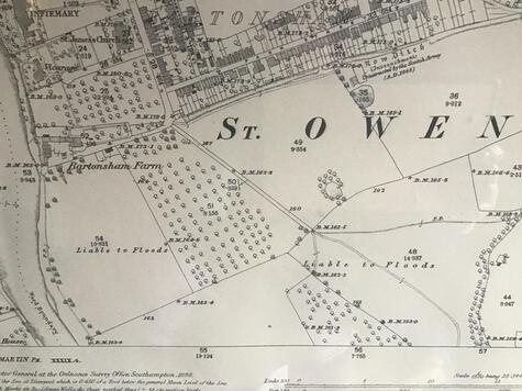
The ordnance survey map from 1888 also shows lots of trees over the fields. I think these are orchards. I seem to remember reading something from a history site about the ragamuffins pinching fruit from the orchards at the end of Green Street. Interestingly ‘Liable to Floods’ is also marked on the map across the fields.
There is also a little pond marked in the field below park street houses. This is also visible on the aerial photo. Does anyone remember this?
| | Click on 'Comments' below, to reply and add your own comments or check our Facebook page to join in the conversation. |

 RSS Feed
