from History Group member Naomi Bell
Although both the Oxford and Cambridge books of English Place Names give the definition of “Barton” as Barley Farm, I am not satisfied that this is the only definition. On consulting the West Somerset Word Book of 1888, I find the following:-
“That part of the farm premises which is specially enclosed for cattle . . . because it is here that large quantities of straw are strewed about to be eaten and turned into manure . . .The term ‘Barton’ is also applied to the entire farm and homestead, but in this case it is only to the more important farms; very often it is the principal farm in the parish, whether occupied by the owner or not – generally not.”
Also see Thomas Hardy’s poem “The Oxen” which contains the lines
“Come, see the oxen kneel in the lonely barton in yonder combe”
I realise that Bartonsham is in Herefordshire, not Somerset or Dorset but vocabulary doesn’t necessarily change at county boundaries. It would be good to find out if a Herefordshire word book would give a similar definition for “barton”.
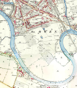
Having looked into the meaning of the place name element “Barton” and discovered that it can also be defined as above, I the looked into the meaning of “Ham”, using the Oxford dictionary of Place Names. It is true that “Ham” often means “homestead” but it also has other meanings, including “Land hemmed in by water or higher ground, or land in a river bend”, all from OE Hamm. E.g. Evesham -“Land in a river bend belonging to a man called Eof.” Bodenham – “Homestead or river-bend land of a man called Boda”. See also Twickenham, Keynsham etc.
So we could now define “Bartonsham” as “large farm and homestead in a river bend” which I believe gives us a much more accurate definition of this place name.
A large part of the 1843 Tithe Map fields have subsequently been built on. Middle Piece and Lower Piece, and Orchard containing the alms-houses and vicarage etc are all marked as arable and all escaped the record-breaking floods of early 2020. The only portion of the large meadow behind Park Street, marked as arable is at the east end is the half of Eign Meadow adjacent to the Row Ditch. It is very likely that barley among other crops was grown on these fields – it was much in demand for brewing and fodder.
The remaining fields with the exception of Old Hopyard and half of Meadow Below Fold (both orchards) are marked M&P, (meadow and pasture]. COED defines “meadow” as piece of grassland, esp. one used for hay; low well-watered ground, esp. near river. Chambers definition is similar – a tract of grassland, esp used for hay; a rich pasture-ground, esp beside a stream. Within Hereford both Merton Meadow (pre car park!) and Lugg Meadows also fit this definition.
So it would seem that the fields we know as Bartonsham Meadows have provided grazing for cattle for around 180 years and probably far longer.

 RSS Feed
