INTRODUCTION TO HISTORY OF BARTONSHAM MEADOWS
Click on blue text to view links to relevant pages on the web site
The Meadows were grazed by a milking herd at Bartonsham Farm, for as long as anyone can remember and for the past century by the Matthews’ family of Eaton Bishop. The land which is owned by the Church Commissioners, was leased to the Matthews in 1920 for three generations: John William, Thomas Stanley and John Edward, who had the final tenancy.
An easy relationship between the Matthews family - particularly Stan and his son John - and local people ensured that the landscape, botanical and historical qualities of the Meadows were appreciated and cherished by generations of people living close to the centre of Hereford. See Bartonsham Dairy
The fact Hereford still had a 120 acre working farm with its own dairy within a stone's throw of the City Walls was remarkable. In 2021, however, the farm ceased producing milk and in the spring of 2023 a 25-year lease was signed with Herefordshire Wildlife Trust to manage the Meadows as a nature reserve. It is thanks to the fact that, being in the flood plain, development for housing stopped abruptly at the Row Ditch, the scheduled ancient monument that marks the frontier of the City's growth reached by the 1850s. Beyond the ditch the land is low-lying and, with the exception of an area taken out of it by the Victorians for the Treatment Works, survived intact - complete with a rich archaeological legacy.
Historian David Whitehead:
Bartonsham and its meadows rank as one of the key elements in the city of Hereford’s history.
By the mid-13th century there was a *prebendal estate of Bartonsham, which was endowed with lands in the parish of St Owen. In 1866 these were transferred by Prebendary Hopton to the Church Commissioners for the endowment of the new church of St James. The extent of the estate is unknown – did it include Bartonsham Farm?
The creation of prebendal estates occurred after the Norman Conquest and it seems likely that Bartonsham had an earlier history quite distinct from the Cathedral.
The Cambridge Dictionary of English Place-Names (2004) states that ‘barton’ or in Old English beretun or baertun was ‘a corn farm, an outlying grange, a demesne farm, especially one retained for the lord’s use and not let to tenants.’ It also adds that the name implies a settlement which was originally a component of a larger unit. After 1066 this appears to be one of the many estates around the city of Hereford collectively forming the patrimony of the church. On the west side of the city there was another ‘barton’ remembered today as Barton Road.
At Bartonsham the arable lands that produced the corn, i.e. the barley, may have come from the present meadows, since the Wye was probably better mannered in the distant past. On the other hand, the arable lands may have been at the south- eastern end of the Port Fields, which surrounded the immediate hinterland of the early city. The suffix **ham or hamm can either be a generic name for ‘homestead’ or just as frequently, a water meadow
It seems Bartonsham was part of the ancient patrimony of Hereford’s earliest church; one that pre-dates the foundation of the cathedral and around which the royal liberty of Hereford - 4,820 acres today - was established, outside the later jurisdiction of the shire. Archaeological evidence shows that burials in the vicinity of the original church on Castle Green extended back to c.700 AD – and probably earlier since the excavations in the 1970s were never bottomed. Bartonsham was thus, the home farm of St Guthlac’s and also the royal palace – mentioned in Domesday Book - which the Mercian kings attached to it.
* Prebend, or Prebendary;
the stipend assigned by a cathedral or collegiate church to a canon or member of the chapter. The land, tithe, or other source of such a stipend.
** see name on map for Bartonshams Historic Mills link - 'Bartons Ham'
the stipend assigned by a cathedral or collegiate church to a canon or member of the chapter. The land, tithe, or other source of such a stipend.
** see name on map for Bartonshams Historic Mills link - 'Bartons Ham'
The Bartonsham Meadows lie nestled in a bend of the Wye. As a flood plain it was, and is, regularly washed over by winter floods to emerge in spring enriched with a layer of fertile, riverine silt. Natural flooding puts the necessary nutrients in the ground for good grazing and hay at no cost.
But was it also a water meadow? Water meadows are, or were, carefully managed to maximise the benefits of a rich pasture, what one Grosmont farmer called his ‘butter meadows’. Skilled water ‘drowners’ were employed to create and manage the ridges, furrows and ditches that irrigated the meadows. This brought forward the grazing season and kept the grass growing during dry weather.
|
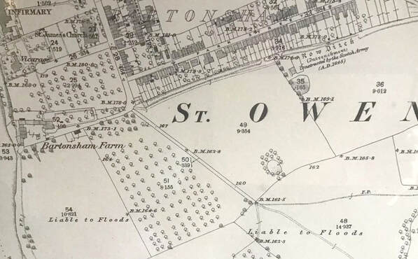
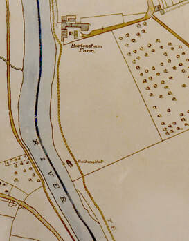
Cropped section of 1847 tithe map of St. Owen. Originaly digitized at the National Archives by David Lovelace.
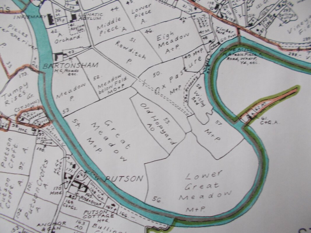
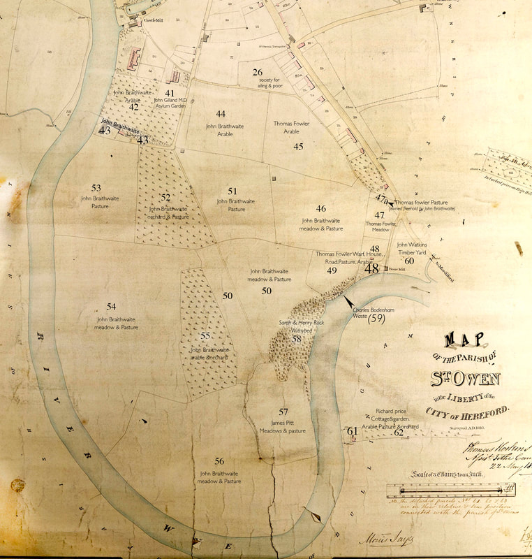
Superimposed details of occupancy and usage on various fields, are referenced to the numbered entries on Tithe payment documents which are held at Herefordshire Archives and Records Centre. Click here to see a summary of the details, including ownership. |
Research by landscape archaeologists suggest Bartonsham’s fields were managed as water meadows, the source of their floodwaters being linked to the milling industry
David Whitehead and David Lovelace:
Herefordshire Water Meadows
The extensive area of river-side pasture to the south-west of the city’s castle and cathedral, the Bartonsham Meadows, was separated from the arable lands of the city's Portfields by the Row Ditch, traditionally regarded as a military entrenchment.
Herefordshire Water Meadows
The extensive area of river-side pasture to the south-west of the city’s castle and cathedral, the Bartonsham Meadows, was separated from the arable lands of the city's Portfields by the Row Ditch, traditionally regarded as a military entrenchment.
|
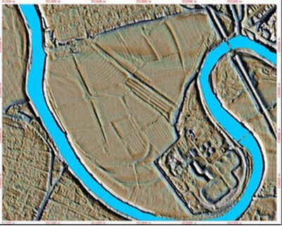
Aerial photography and more recent Lidar (laser scans of the landscape) have revealed a system of ridged earthworks covering the meadow(s), which have usually been regarded as ridge and furrow. However, the Ditch runs from the Wye, just below the Castle Green at Bartonsham Farm, across the meadows to the Wye again at Eign, cutting off a large area of alluvial grassland.
Until the late 17th century mills occupied a weir ... at Bartonsham; it therefore seems very likely that the Row Ditch was a carrier for an irrigation system on the Bartonsham Meadows supplied by excess water impounded for the mills, which, in 1697, had a weir five feet high and a lock. The mills were subsequently demolished to make the river navigable. See Bartonshams Historic Mills |
Similar flood plains sometimes served as a functioning water meadow. A functioning water meadow, explains David Lovelace, required a controlled water course, often one provided by the waters emerging from a mill pond, the so called tail-leat. (There was a strong link between water meadows and mills – as at Lugg Mill). There is, as yet, no evidence to suggest the Bartonsham meadows were fed in this way.
More research is needed before any further evidence is destroyed.
More research is needed before any further evidence is destroyed.
Public Access to the Meadows
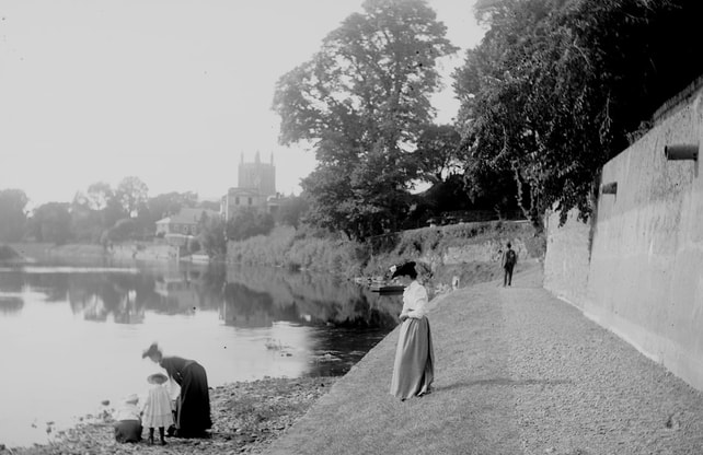
Locals have unto this day enjoyed walks around the meadows. Apart from the recently noted permissive path which rums along the course of the old Row Ditch, there have always been two public rights of way; one which was originally a bridleway from the end of Green street, and another which was a hard fought for path, running from the Castle Green to the Whalebone Inn at Eign Warf . The right of access to this route was often contested.
In April 1862 The Hereford Times published this testimony from parishioner William Preece:
|
“About 70 years ago, a person named Yeats held the Bassom estate; he attempted to stop up the pathway next the river, leading to the Whalebone at Eign; this was resisted by the inhabitants of Hereford, and the Churchwardens of the parish, and other persons, of whom I was one went to the Bassom and removed the obstacles. Within a short time Yeats stopped up the path way again, and again we assembled and opened it; Yeats then gave up all opposition to the public passing there. After Yeats, a person named Moor lived at the Bassom, he had married Yeats daughter, I was intimately acquainted with him, he lived there many years – I think more than 20, he never attempted to interrupt the public passing through the meadows during his occupancy. Of late years Mr Braithwaite, during his possession of the Bassom farm, twice stopped up the pathway; I assisted Captain Blair, Mr Tully and others to force a passage, and we obliged Mr Braithwaite to acknowledge the public right by his giving up his attempt to stop the right of way.
I also recollect a branch of the river passing on the Hereford side ‘Withy-bed’ at Eign, now belonging to Mr Bodenham of Rotherwas; the public path in question ran by the side of this branch. I am now in my 88th year; I have during my life taken much interest in the parochial business of St Owens and have from time to time passed along this path; I have been there with the rev Mr Jennings, the rev Mr Freeman, and many other parisioners, and I can positively declare that a right of foot-way has always existed on the brink of the river through the Bassom meadows to Eign. “ |
The newspaper described Preece as: “One of the oldest and most respectable of our fellow citizens; indeed we believe he is the father of the city”.
The battle of rights of way along the river continued. Originally there had been a controversial footpath through the Infirmary gardens to the ‘Bassom’ Meadows and while some considered it detrimental to the patients’ health, others thought a good walk important for the citizens. As the old Castle Mill on Mill Street was to be demolished in 1881, there was much debate over the future of the land. Eventually it was decided to move the pathway from the Infirmary grounds to run over the demolished mill land alongside the river under a new infirmary wall.
The battle of rights of way along the river continued. Originally there had been a controversial footpath through the Infirmary gardens to the ‘Bassom’ Meadows and while some considered it detrimental to the patients’ health, others thought a good walk important for the citizens. As the old Castle Mill on Mill Street was to be demolished in 1881, there was much debate over the future of the land. Eventually it was decided to move the pathway from the Infirmary grounds to run over the demolished mill land alongside the river under a new infirmary wall.
|
In more recent times The public also enjoyed access to the river from the Meadows, at ‘The Bassom’ just below the farm. This was where most people learned to swim. In May 1915 with the country at war, the Hereford Times reported that, with the river in ‘a splendid condition, being both fresh and of a comfortable temperature, the advent of summer weather saw bathing commenced in the Wye at the Bartonsham Bathing Station, maintained by the Town Council. On one occasion in September 1913 air ace Bentfield Hucks. Landed his 80 horsepower Gnome Blériot monoplane on the Bartonsham Meadows. Offering flights to the public, for £5 a ticket, which in those days was expensive. |
To read a more detailed account of the Meadows History, and the river that surrounds them, download our pdf historybartonshammeadows.pdf.
